Overhead pass 8 readings
- Pass under way
- Elevation above the horizon
- Ground distance
- Distance to the station
- Next pass at
- Minutes until the next pass
- Peak elevation of the next pass
- Next pass visible to the naked eye

App for Homey Pro
Know when the space station flies over, and when it can be seen.
Available v1.1.2
The International Space Station circles the Earth in ninety-two minutes and flies over your home several times a day. The app computes those passes a day ahead, for the position of your Homey, and above all tells apart the ones you can see with the naked eye, which needs three things at once: the station lit by the Sun, your own sky already dark, and enough height to clear the rooftops. A Flow can then switch on a light or warn you a few minutes ahead.
View on the Homey App Store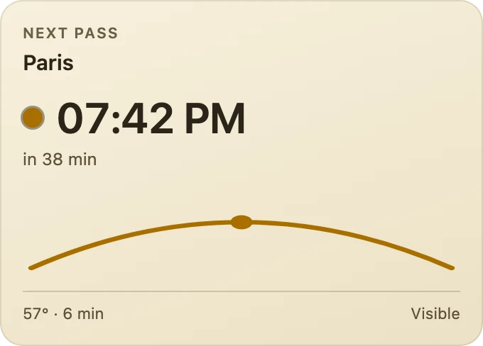
The time of the next pass in large type and how long until it, then the arc of its course drawn at its true height, higher for an overhead pass than for a grazing one. The dot and the curve turn gold when the pass can be seen with the naked eye.
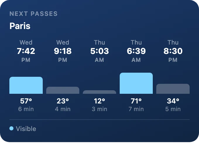
One column per coming pass, three to six of them: the day, the time, a bar as tall as the station will climb, its height and its duration. The passes visible to the naked eye stand out.
Predicting a pass means knowing where the station will be, where that puts it relative to you, and whether you will be able to see it. The three questions are handled separately, and the third is the one where mistakes are easiest.
01
le service répond aux instants futurs, jusqu'à 24 h, balayage au pas de 60 s, 30 instants par requête
There is no orbit propagator on board, and that is deliberate. The service accepts a request for the position at a future instant, up to twenty-four hours ahead, so the window can simply be scanned minute by minute. A whole day costs forty-nine requests, against a stated quota of three hundred and fifty per five minutes. The scan runs only at startup, at midnight, and on demand.
02
γ = 2·arcsin( √( sin²(Δφ⁄2) + cos φ₁ · cos φ₂ · sin²(Δλ⁄2) ) )
This is the angle at the Earth's centre between your home and the point directly under the station. It uses the haversine formula rather than the direct cosine, which loses all precision when two points are close, which is exactly when the station passes overhead. A test exercises it on two points a metre apart.
03
h = arctan2( cos γ − R ⁄ (R + a) , sin γ )
This is what the eye sees, and so the quantity that decides everything. The two-argument arctangent is used rather than a division, which would give infinity at the zenith, where the sine vanishes. The device setting acts on this height, ten degrees by default: below that, a pass is swallowed by roofs and trees.
04
d = √( R² + (R + a)² − 2 · R · (R + a) · cos γ )
The distance to the station is the chord through space, given by the law of cosines. The ground distance is the arc travelled over the surface, R times the angle. When the station is far, the arc is longer than the chord, which is surprising on the tile but perfectly correct: at a hundred degrees apart there are nearly eleven thousand kilometres of ground for ten thousand as the crow flies.
05
rayon de visibilité = R · arccos( R ⁄ (R + a) ) ≈ 2 257 km à 420 km d'altitude
This is the radius of the circle from which the station stands above the horizon. The service publishes a footprint of its own, the diameter of that very circle, so the two can be compared. The measured gap is 1.34 kilometres out of 2,258, six hundredths of one per cent, which matches the choice of Earth radius, mean here and equatorial there. The geometry is thus validated without having to take the service at its word.
06
la station est éclairée si γ(station, point subsolaire) < 90° + arccos( R ⁄ (R + a) )
The service publishes a field called “visibility”, and trusting it would be a mistake. It describes the ground under the station, not the station: it answers “daylight” when it is day below, even though the station is in full sunlight and perfectly visible to a distant observer in the dark. Relying on it led to the conclusion that no pass was visible over twenty-four hours; computing the illumination from the subsolar point, which the service also supplies, brought out two passes, both in the small hours, which is indeed when the station is seen at this time of year. The Earth's shadow is treated as a cylinder, and the altitude adds some twenty degrees to the half-angle.
07
hauteur du Soleil chez l'observateur < −6°, le crépuscule civil
This is the condition the service does not provide and which has to be computed here: a lit station crossing a daylit sky stays invisible. The Sun's elevation comes from the NOAA equations, the same as in the Ephemerides app, and the two implementations were compared: they agree to a ten-thousandth of a degree on a value read in operation.
08
un passage = les instants consécutifs où h > 0 ; retenu si son sommet atteint la hauteur minimale
The scanned series is cut into runs of consecutive instants where the station stands above the horizon. Each run gives a pass, of which the start, the end, the peak and its azimuth are kept. Those whose peak falls short of the configured height are discarded, and a pass is declared visible only if one of its instants meets all three conditions at once. The distance card, for its part, fires only on a downward crossing: otherwise it would fire again at every reading for as long as the station stayed inside the radius.
Homey writes an automation in three parts: when something happens, and if a condition holds, then do this. Anything on a lighter background, such as radius, is a parameter you set in the Flow. Every condition also exists in its negative form, which Homey flips with one click.
When 4
And 3
Then 1
ISS 1.1.2 gives the two dashboard widgets a fresh look.
As before, Next pass shows the time of the next pass, how long until it starts, an arc drawn at the height the station will reach, and its peak elevation and duration. Next passes lines up the coming passes, each bar as tall as the station will climb, with those visible to the naked eye highlighted.
Next passes lets you choose how many passes to show, from 3 to 6, and whether to keep only the visible ones; it also works well on a wide tile. Both widgets offer five backgrounds: deep blue, slate, plum, forest or sand.
The passes are computed from your Homey's location, so the app works wherever you are, not only in France.